From the foundational role of Geographic Information Systems (GIS) to the transformative impact of Building Information Modelling (BIM) and the emergence of digital twins, Steven Eglinton FRGS takes us through the evolution of asset management in this guest blog.
Steven explores the progressive shift towards a digital ecosystem and setting new standards for sustainable and efficient asset management.
From GIS to BIM and beyond
My professional journey began with Geographic Information Systems (GIS), where I developed an essential understanding of geospatial data as a cornerstone for effective asset management. This stage was critical, underscoring the importance of geospatial information in providing context and intelligence to physical assets. It became clear that GIS extended beyond traditional mapping, enhancing asset management through detailed spatial analysis and thereby improving planning, decision-making, and operational efficiency.
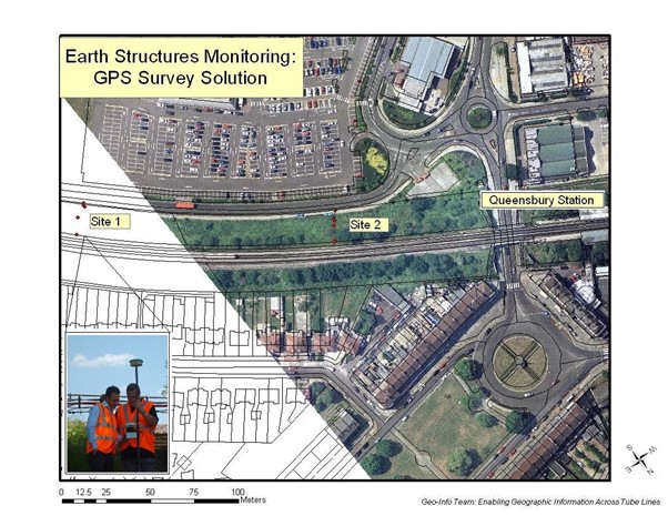
The image below shows work from the London Underground (Tube Lines) I led when I was the Head of Geospatial Information, to transition earth structures (embankments and cuttings) asset inspections into a more digital, and geospatially-enabled phase. For those that are non-survey professionals we used Real-time kinematic positioning (RTK). This is applied to surveying to correct for common errors in current satellite navigation (GNSS) systems. Things have come a long way and I can think of a few ways to improve things now!
Embracing building information modelling (BIM)
Moving into Building Information Modelling (BIM), I explored the transformative impact of digital models in asset design and construction. BIM enriched traditional design processes with detailed digital representations, capturing the physical and functional traits of assets. This experience highlighted the benefits of integrating BIM with geospatial solutions, optimising construction processes and establishing a solid foundation for future asset management strategies.
Advancing towards digital twins
In my current role, focusing on Digital Transformation and Information Management, the fusion of GIS and BIM experiences illuminated the pathway to creating a unified digital ecosystem for asset management. The emergence of digital twins has been a key milestone, providing dynamic digital replicas of physical assets, enriched with real-time data. These virtual models enable advanced analysis, monitoring, and predictive maintenance, bridging the gap between the physical and digital realms.
Geospatial solutions as the backbone
Central to this ecosystem is the role of geospatial information and solutions, serving both as the foundational layer and the intuitive interface through web maps, 3D visualisations, and dashboards. This integration simplifies complex asset data, empowering stakeholders with comprehensive insights for informed decision-making.
The future landscape of asset management
The evolution from GIS and BIM to digital twins represents the transformative journey of asset management into the digital era. This evolution envisions an integrated future, where digital and physical systems coexist seamlessly, ensuring sustainable, efficient, and resilient management of national-level assets. By capitalising on the strengths of geospatial information and the advanced functionalities of digital twins, we’re setting new standards for asset management, aiming for a more interconnected, sustainable, and efficient built environment.
Discover more about asset management
For further insight into asset management, a podcast featuring David McKeown, Honorary Vice President of the Institute of Asset Management (IAM), and myself, offers a comprehensive discussion on managing assets beyond their physical presence towards a holistic approach.
For additional resources and information about asset management, The Institute of Asset Management (The IAM) website is an invaluable resource.
Steven Eglinton FRGS, FBCS, FBCart.S, MIoD, MPWI
 Steven was initially a representative for the Association for Geographic Information (AGI), where he was a Council Member and Director. He now represents the Institution of Civil Engineers (ICE), where he teaches Information Management and the ‘UK BIM Framework’ (ISO 19650).
Steven has over 24 years’ experience as an expert in Information Management (IM); Digital, Data and Technology (DDaT); infrastructure asset management and Geospatial solutions. His has had a diverse career across most disciplines and industries; from managing GIS and enterprise asset management in the Rail sector, to data developing data interoperability and dashboards for Public Sector property management (PropTech). Steven is currently a Senior Consultant at the Work Bank in Asset Management Systems and is a Director of GeoEnable and BimEnable.
Steven is the founder and host of the BimTube Podcast – whose mission is to explain the benefits and outcomes of ‘Better Information Management’ for Digital, Data and Technology (DDaT) – including geospatial solutions – without using technical jargon!
 By Grace Donnelly