Tailings dams are large earth embankments used to store toxic mine waste. When these structures fail they can result in death, destruction and long term pollution.
Here, Maral Bayaraa discusses the Satellite Applications Catapult’s research into using Earth Observation (EO) technology to create a satellite-based monitoring system to forecast potentially catastrophic failures.
Mining is at the core of our global energy transition. If we are to avoid the existential threats posed by climate change and ecological collapse, and remain within the Paris commitment of average temperatures of well below 2o C, an estimated 3 billion tons of metals will be required[1].
To put this in context of the challenge set to the extractive industries, this number is small compared to the amount of material that will need to be taken out of the ground. For example, over 98% of the material in copper mining being waste. Therefore, the often forgotten consequence of our metal hungry future is the handling of the enormous amount of resulting mine waste.
Usually, mine waste are stored behind earthen dams, referred to as ‘Tailings Storage Facilities’ (TSFs). Unfortunately, when TSFs collapse, the consequences can be devastating. For example, the Brumadinho failure of 2019 resulted in an environmental tragedy, costing an estimated USD 7 billion[2] in compensation. Given that mining is one of the oldest industries, over 30 000 TSFs are estimated worldwide (World Mine Tailings Failures initiative), with quarter of which are abandoned, therefore, not monitored at all.
The innovation in the earth observation industry demonstrate the important role for satellite technology in global infrastructure monitoring. The aspiration of our research is to help create remote, satellite-based early warning system and ensure that any dangerous behaviour are detected well in advance.
Satellite Applications Catapult is a non-for-profit, UK government backed, research and technology organisation acting as a bridge between academia, industry and the government. As well as being a source of technical and scientific ideas leading to new products and services, our ambition is to help societies adapt to emerging technologies and thus support continued innovation.
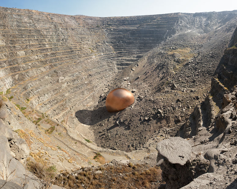
This image from photographer Dillon Marsh demonstrates the enormous amount of waste that comes from mining.
Satellite InSAR in infrastructure monitoring
From hundreds of kilometres in space, satellite interferometric synthetic-aperture radar (InSAR) analysis allows detection of ground movements on a millimetric scale. There is a wealth of literature on the application of InSAR to the monitoring of natural hazards, including earthquakes, landslides and volcanology[3]. Increasingly, the availability of more synthetic aperture radar (SAR) constellations with greater temporal and spatial resolution has prompted an InSAR renaissance. While SAR data refer to the raw satellite data, InSAR data refer to the processing chains of techniques used to estimate ground movement from the phase difference of SAR acquisitions. Recently, modified multi-temporal InSAR techniques have been adopted to monitor critical infrastructure such as bridges[4] and TSFs containing mine waste. Although relatively sparse, an increasing number of studies have explored the use of InSAR to monitor tailings dams. A common aim of these studies is to identify dam deformation signals which are precursory indications of structural failure, such as the Brumadinho[5] and Cadia failures[6].
InSAR and geotechnical
Our study in Bayaraa et al (2022)[9] created the first systematic demonstration of the efficacy and complementarity of geotechnical and remote sensing techniques for the monitoring of TSFs. It demonstrated that satellite InSAR deformation measurements are comparable to traditional geotechnical approaches such as ground-based prisms and numerical modelling. Through comparisons to prism monitoring, InSAR was shown to provide reliable measurements of the temporal development of ground deformations for TSFs. The InSAR monitoring also revealed the existence of important and complex spatial and temporal variability of the dam deformations which were not captured by the traditional point-based prism monitoring. These results revealed anomalous deformation trends up to one year preceding the dam failure which are inconsistent with expected consolidation settlements of the dam. This suggests that, combined with geotechnical expertise, there is potentially ample time to trigger early warning alerts for tailings dams.
Future vision
The combination of latest AI techniques with remote sensing techniques is already revolutionising the art of what is possible from EO[10]. The challenge in TSF monitoring is to differentiate between typically ‘normal’ versus dangerous or ‘anomalous’ in the InSAR and other datasets. Currently, data science experiments are being undertaken on the InSAR data exploring the feasibility of various novel ML and traditional forecasting approaches. Preliminary results show much promise for detecting anomalous deformation signals as early warning of TSF failure.
Sources
- [1] K Hund, D La Porta, TP Fabregas, T Laing, and J Dexhage. Mineralsfor climate action: the mineral intensity of the clean energy ransition. climate-smart mining facility, 2020.
- [2] https://www.reuters.com/article/us-vale-sa-disaster-agreement-idUSKBN2A41V5
- [3] Biggs & Pritchard (2017). http://elementsmagazine.org/2017/02/02/global-volcano-monitoring-what-does-it-mean-when-volcanoes-deform/
- [4] Cusson et al (2020). https://link.springer.com/article/10.1007/s13349-020-00446-9
- [5] Stephen Grebby, Andrew Sowter, Jon Gluyas, David Toll, David Gee,Ahmed Athab, and Renoy Girindran. Advanced analysis of satellitedata reveals ground deformation precursors to the brumadinhotailings dam collapse. Communications Earth & Environment, 2(1):1–9, 2021.
- [6] Tommaso Carl`a, Emanuele Intrieri, Federico Raspini, Federica Bardi,Paolo Farina, Alessandro Ferretti, Davide Colombo, FabrizioNovali, and Nicola Casagli. Perspectives on the prediction ofcatastrophic slope failures from satellite insar. Scientific reports,9(1):1–9, 2019
- [7] A Thomas, SJ Edwards, J Engels, H McCormack, V Hopkins, andR Holley. Earth observation data and satellite insar for the remotemonitoring of tailings storage facilities: a case study of cadia mine,australia. In Proceedings of the 22nd International Conference onPaste, Thickened and Filtered Tailings, pages 183–195. AustralianCentre for Geomechanics, 2019.
- [8] Rebecca Hudson, Shinya Sato, Roger Morin, and Mary AnneMcParland. Comparison of sentinel-1 and radarsat-2 data formonitoring of tailings storage facilities. In EUSAR 2021; 13thEuropean Conference on Synthetic Aperture Radar, pages 1–6,2021.
- [9] Bayaraa et al (2022). https://www.icevirtuallibrary.com/doi/abs/10.1680/jgeot.21.00399
- [10] White Paper on AI for EO: https://sa.catapult.org.uk/digital-library/white-paper-state-of-ai-for-earth-observation/
 By Grace Donnelly